


ITB Berlin 2012, salah satu album di Flickr.
Flores Exotic tours, one of indonesian exhibitor at ITB in Berlin 7-11 March 2012.
Discovering Indonesia beyond Bali KOMODO | FLORES | SUMBA | WEST TIMOR | ALOR - adventure tours - Photography tours - Eco-tours - Cycling. www.floresexotictours.id - www.komododragontours.com
Showing posts with label exotic. Show all posts
Showing posts with label exotic. Show all posts
Thursday, March 22, 2012
Monday, January 23, 2012
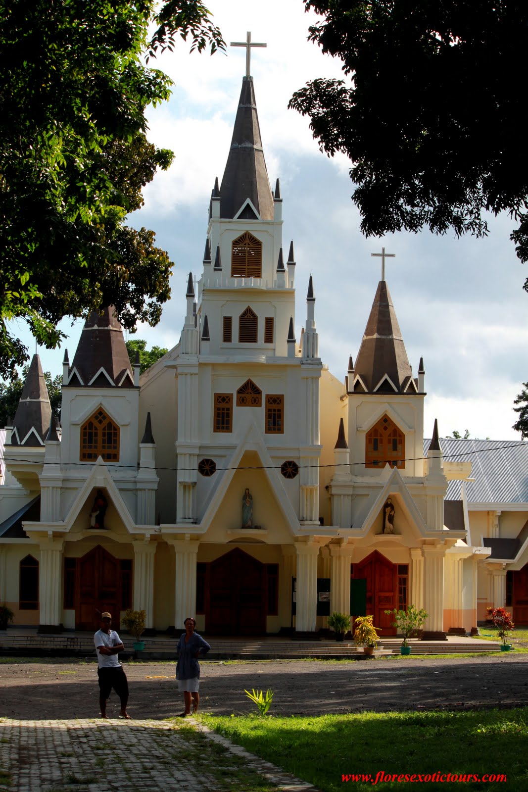
Semana Santa, Larantuka Flores
THE LARANTUKA “SEMANA SANTA” UNIQUE HOLY WEEK CELEBRATIONS

Each year, the week before Easter Sunday, the town of Larantuka, East Flores, solemnly celebrates the Holy Week, popularly known here as “Semana Santa”. The pinnacle of these celebrations is the commemoration of Christ’s suffering on Good Friday by following the stations of the Cross, known here as the “Sesta Vera”. In Larantuka, prayers center around two religious icons, one is the statue of Jesus Christ (locally known as Tuan Ana) and the other is that of the Virgin Mary (Localy known as Tuan Ma). Both are original statues brought here by Portuguese missionaries Gaspar do Espírito Santo and Agostinho de Madalena in the 16th century. These statues are presented to the public only during Easter and are kept out-of-view for the rest of the year.
Located on the eastern tip of Flores Island, - Larantuka,- also known as ‘Kota Reinha’ or ‘Tana Nagi’, is the capital of the district of East Flores.

Having strong Portuguese colonial influences, the town is commonly known as one where Catholicism flourishes in Indonesia. For more than four centuries, this region inherited Catholicism through the role of the common people rather than through the clergy. The King of Larantuka, missionaries, the brotherhood of apostles of the common people (Confreria), the Semana Tribe, and the Kakang (Kakang Lewo Pulo Tribe) as well as the Pou (Lema Tribe) have played pivotal roles in the development of Catholicism in this Larantuka region.
During Holy Week, the normally quiet and tranquil town will be filled with pilgrims and congregations from many parts of Indonesia and from around the world.
The Semana Santa commences with the Rabu Trewa or the Shackled Wednesday (or Ash Wednesday) on the mid-Easter week. On this day, devotees gather in chapels and pray, remembering the betrayal of Jesus by Judas Iscariot which led to Jesus’ arrest and shackling. This is the time when the town of Larantuka turns into the Town of Mourning; a time when it drowns into solemnity and reflection for the purification of the soul.
In the afternoon of Maundy Thursday, devotees enact the tikam turo ritual in preparing the route for the following day’s seven kilometer procession by planting candles along the route. At the Chapel of Tuan Ma (Virgin Mary) the casket that has been sealed for one year is carefully opened by the Conferia, and the statue of Tuan Ma or Virgin Mary is bathed and then dressed in mourning clothes (a piece of black or purple, or blue velvet coat).
The pinnacle of the rituals falls on Good Friday or the Sesta Vera. The door of the chapel of Tuan Ma and Tuan Ana (Jesus and the Virgin Mary) opens at ten o’clock in the morning. The Good Friday procession is highlighted by the ritual of carrying the body of Jesus Christ, placing Jesus at the center of the ritual and placing Mother Mary at the center of attention, as the mourning mother (Mater Dolorosa). The Sabtu Santo (Holy Saturday) and the Minggu Paskah (Easter Sunday) follow the next days, marking the end of the entire Easter week procession.
Tuesday, April 26, 2011
Flores: Hidden flower of the East
Flores: Hidden flower of the East
The Jakarta Post, Jakarta | Sun, 09/04/2005
Christina Schott, Contributor, Jakarta
Flores. For years we wanted to go Cabo da Flores (Cape of Flowers), as the Portuguese called the island in today's East Nusa Tenggara when they first arrived in 1512. Whether they chose this name because of the beautiful vegetation or because of the colorful underwater gardens is not clear. Both are overwhelming in the right season; just after the rain is over, when the mud has dried but the dust has not yet risen.
That was the moment, as we sat on a flight to Maumere, we had the idea to roll east to west along the Trans-Flores highway. From the air, we got the first impression of the breathtaking landscape waiting for us: Flores, 375 kilometers long but extremely slim, presents dramatic mountain scenery up to 2,400 meters above sea level and 14 active volcanoes. And even from high up we could see the clear turquoise water around the northern coast, with its coral reefs that promised to fulfill every diver's dream.
As an important junction, Maumere is a good place to start in, although the town was mostly destroyed by a devastating tsunami in 1992. Since there was not even a fraction of the international attention last year's tsunami drew, the thousands of victims had to rebuild their homes with few donors in a rather unattractive way. However, some quiet bungalow resorts on the way to Larantuka -- once the headquarters of the Portuguese Dominicans -- provide pristine, white sandy beaches and access to snorkeling and diving spots.
Very soon, however, we learned that transport on Flores not only needs time but it also has its price: Either you pay in U.S. dollars for a private car or you bump your body around chicken cages and other loads piled up in the middle of a public bus. We chose the second option, hoping to get some travel originality. We got it. With three goats and a pig screaming on top of our heads and the finest selection of East Nusa Tenggara hits of the Eighties. All at full volume, of course.
We also understood quickly, why every passenger on the bus was greeted with the distribution of plastic bags. The ""Trans-Flores-Highway"" is, indeed, the biggest road on the island but that doesn't mean much, since it is often the only asphalted one. It is an ever-winding mountain pass road that hardly provides enough space for two buses passing each other, let alone the potholes. ""Nothing compared to 40 years ago,"" reassured a retired missionary who had first arrived on Flores in the 1960s. ""At that time, the trip to Ende took us a whole day on dusty earth.""
Nevertheless, the stomach- and buttock-torturing journey was worth every kilometer for its gorgeous panoramic views. We needed four hours to our first stop at Moni, the gateway for a visit to Mount Kelimutu, whose three-colored crater lakes are one of Flores most famous tourist attractions. Early in the morning, two hired motorbikes took us to the freezing dark on top of the volcano. Every story the villagers told us the night before about ghosts and other mysteries suddenly seemed very real.
From the parking still half-an-hour-climb through the fog, we reached the platform on the top just in time to imagine the sunrise behind the impenetrable clouds. Thanks to our sarongs and thermos bottle with hot tea we could stand the cold a little longer than the disappointed Dutch travel group that arrived with us so that we were on our own to witness the sun breaking through and turning the three dark water holes around us into the bubbling crater lakes we were hoping for. Because of unexplored chemical reactions the color of the lakes have changed several times in the last decades, leaving them now in a shimmering black, sparkling turquoise and rusty dark brown. The souls of the dead are said to live here and we could imagine them dancing in the steam rising up the steep slopes.
After a two-hour bus ride and a 15 degree Celsius difference in temperature we reached Ende. The capital of Flores doesn't offer much as a tourist attraction except a dirty harbor and one of the island's three public Internet cafes; the others are in Maumere and Ruteng. It is also a good place to buy famous ikat (traditional weaving) made all over the island and to prepare oneself for the freezing nights at the next stop in the mountains: Bajawa.
The main town of the Ngada region is -- beside Labuanbajo -- probably the best-prepared for travelers. Everything is organized by local guides and the bemo (three-wheeled motor taxi) mafia, and even their tour prizes are fixed. But you need them: We probably would never have found our way to the traditional villages of the Ngada people alone. A few kilometers can become a long winding way through an unknown forest. Another problem is the language: not all of the indigenous people speak Indonesian. As different as the climate on Flores is, as different are the peoples, their features and their languages.
The Ngada normally live in matriarchal communities with strict sacred rules. Although they were converted to Catholicism -- the graves in front of their towering wooden houses show crosses -- they still follow many animist traditions. Among the crosses, there are megalithic altars and a lot of other symbols like the ngadhu and bhaga, reminding us of the female and male ancestors of every clan living in the village. On top of these open graveyards play the children along with cats and pigs, as the mothers weave the traditional black-and-white ikat. But behind their brown stained smiles -- what the sirih (betel) addiction left of their teeth -- lurk symbols of modernity; Coca-Cola boxes in the back of their houses.
After a soothing bath in the nearby hot springs of Soa, we are ready for our last bone-shaking bus trip next morning. It starts with an impressing tour around Mount Inerie, and offers direct views to the sea from the top of the peaks before reaching the Manggarai capital Ruteng. From there it is still another four-hour-drive to Labuanbajo. This bustling harbor town is mainly inhabited by Muslim immigrants from Sulawesi and is the starting point for all kinds of boat trips to the innumerable islands between Flores and Sumbawa -- before all go to Komodo National Park.
We need a break after all the bumpy streets and the shouting bus drivers. So we head straight away to Seraya, one of small islands around Labuanbajo; islands which are rented from the government by hotels. Seraya Kecil looks like it was arranged for a travel advertisement: surrounded by white sandy beaches, transparent water and beautiful coral reefs. The island accommodates a small fishing village and -- at the other end -- a dozen simple but clean bamboo bungalows. The only permanent inhabitants there are a couple of deer, a family of dogs and a herd of goats. The rest is all yours.
How to get there:
Flights from Denpasar starting from Rp 500,000 by Merpati or Pelita (to Ende, Maumere, Labuanbajo) and GT Air (to Labuanbajo). PELNI ships go on different routes from Surabaya to Ende, Maumere and Labuanbajo. The trip by public bus and ferry takes around three days from Bali.
Where to stay:
Maumere: Sea World Club, Waiara (13 km from Maumere), Phone: +62-382-21570, www.sea-world-club.com
Ende: Hotel Ikhlas, Jl. Ahmad Yani, Phone: +62-381-21695. Upscale traveler hotel, clean and organized.
Labuanbajo: Those who don't want to stay in the busy immigrant town, should take the Gardena boat to Seraya island and find Robinson's paradise; Seraya Island Bungalows, c/o Gardena Hotel, Labuanbajo. Phone: +62-385-41258, www.serayaisland.com
Transport:
Those who don't want to rely on the uncomfortable public transport or see places off the beaten track, should arrange a car and a guide. Warmly recommended: Leonardus Nyoman, experienced guide, speaks English and German, phone: +62-812-366 2110, Email: leonardus_nym@yahoo.com
Monday, April 18, 2011
Flores Tourist Object
LABUANBAJO
A little town inhabited by fishermen, lies at the extreme western part of Flores Island. The town serves as a jumping off point for the trip to Komodo Island. It is a beautiful area for water skiing, wind surfing, fishing and many other marine activities.
Batu Cermin Cave is five kilometers from the town of Labuanbajo. It can be reached partly by car, and partly on foot. The grotto is 75 by 75 meters large, and contains stalactites and stalagmites. Some tunnels are narrow and dark but in others sunlight falls.
Mbeliling Conservation area: Mbeliling is one of Flores nature conservation area, here life some of Flores endemic birds ie: Flores Hanging-parrot Loriculus flosculus and Flores Crow Corvus florensis, and many other birds, nature pure and rain forest
Lake Sano Nggoang:
Located approximately 35 km east of Labuan Bajo, Thought to be one of the deepest volcanic crater lakes in the world, with recorded depths of 500 meter. Its waters are sulfuric and fed by numerous hot springs . Surroundings: Rural. Agricultural society. Traditional villages, rich in local culture.
Tado Community Eco-tourism: Tado is located approximately 45 km east of Labuan Bajo .Two closely –connected traditional West Manggarai villages, rich in local culture and traditions. Community-based ecotourism villages.
Wae Rebo Traditional Village:
the Authentic Housing of Manggarai, located about 1000m above sea level , in the middle of mountain. All are traditional houses, with really high roofs and they are on 5 levels - the top four are mainly used for storage and all the living areas are on the bottom. We will stay in a house with 8 families. Here you have chance to keep in touch with the people and learnt by seeing, asking, and feeling their culture, life and activities.
R U T E NG
Ruteng is the capital of Manggarai Regency that was once ruled by the kings of Bima. The influences of Bima. The influences of Bima and Goa are evident in prevailing titles, such as Karaeng, and in the manner of dress. The shape of the roofs with the buffalo horn symbol, may be an element inherited from the Minangkabau. The cool town of Ruteng lies at the foot of a mountain. It can be reached by air from Kupang or Denpasar via Bima, or by ferry from Bima via Labuanbajo, or from eastern part via Ende and Bajawa. Beside the fame Komodo lizards, the area has many attractions to offer the tourists, such as the caci dance, a wildlife reserve, and archeological caves
.
Cancar ;Golo Cara; the unique lingko rice fields, circular terraces arranged like a spider web.
Liang Bua: the place where Homo Floresiensis was founded by the archeopathology of new England university of Australia and from Indonesia. The tiny skeleton called Hobbit was discovered during a three-month excavation inside Liang Bua, Scientists believe it may represent a new human species, Homo floresiensis, The species existed alongside modern humans as recently as 13,000 years ago, yet may descend from Homo erectus, which arose some two million years ago.
BAJAWA
The capital of Ngada is Bajawa, which lies in the middle of the cool highlands. It is a pleasant little town such as is seldom found elsewhere in Flores. About 135 kilometers from Ruteng all about 5 to 7 hour - driving distance by car, Bajawa can also be reahed from Kupang by air-craft, and from Ende by car.
Abulobo and Inerie are between mountains with sharp peaks known locally as the "sky pillars", and popular among mountaineers. They are located near coast and have wonderful scenery.
B E N A
Bena is prototype of an ancient Ngada village. Such villages are found in rather great numbers in the area and can be reached by car from bajawa in about one and half hours. The way of life of the people is unique, and so are the houses and the traditional ceremonies.
R I U N G
Riung is now wellknown for its seventeen isles that makes the sea surrounding a paradise for marine lovers. Here one can dive, snorkel, and swim.
The beach is a sea-side resort with clear and calm water. There is a beautiful coral reef just off the shore.
ENDE
Ende was the site of a kingdom that existed around the end of the 1 8th century. The name today refers to the capital of the Ende regency, which includes the two autonomous territories of Lio and Ende. The people of the area therefore known as Lio Ende people. This town has for many decades been a center of government trade, education and political activity. Rebellion against the Dutch, led by a certain Nipa Do - known as the Wars of Watu Api and Mari Longa - decurred here in 1916 - 1917. And in 1934, the traditionalist leader Soekarno, who was later to become Indonesia's first president, was exiled to Ende by the Dutch colonial government.
The town Ende lies at the foot of mountains lye, lpi, Meja and Wongge. The beautiful bays of Ende, lpi, and Mbuu are favorite sites for beach-site recreation. Ende can be reached by aircraft from Kupang. And also from Denpasar via Bima, or by from Surabaya or Kupang.
The Bung Karno Museum is the old house occupied by Soekarno during his years of exile in Ende. Most of for the old furnishings are still there.
While in exile in Ende, Soekarno wrote and staged few plays, together with the Tonel Kelimutu theatre troupe. Among those plays were Rendorua Ola Nggera Nusa (Rendo That Stirred the Archipelago) and Doctor Satan, a revision on the story of Dr. Frankenstein.
Near the football field in Ende stands an old, big breadfruit tree. Under it, Soekarno often sat, working on political ideas to lead Indonesia towards independence. Those reflections presumably contributed to the opening of the Pancasila concept, which is now the state philosophy of the Indonesian Republic. Just from here was the Pancasila idea born. Today, the Pancasila Birth Monument stand on this precise spot.
KELIMUTU
East Nusa Tenggara's natural wonder and one of Indonesia's most mysterious and dramatic sights that can be found on top this mountain, some 66 kilometers from Ende, or 83 kilometers from Maumere. It has a unique and spectacular view on its three crater lakes with their respective colors. The colors, however, have changed continually since the eruption of Mount /ye in Ende in 1969.
The mountain is located at the back of Mount Kelibara, in the Wolowaru District in the Ende, Regency of Central Flores. Keli means mountain and Mutu means boiling. In short, it means volcano. To the local people, this mountain is holy, and a token of God's blessings. It provides fertility to the surrounding lands. It is both heaven and the hell to the people of Lio Ende. Many travelers and scientists, have written about Kelimutu since it was discovered by Van Suchtelen, a Ducth government officer,
in 1915
Father Bouman published an article in 1929, which made the name Kelimutu known all over the world. Since then, many researchers and tourits have come, as well as the Governor General of Batavia (Jakarta). To get to the lakes, one follows the road, from Moni, then proceed to the crater's top. Near the crater rim was a bungalow, which has now been dismantled.
The presence of the white men, or Ata Bara, was regarded disturbing to the peace of the ancestral spirits. As a result the spirits of Kelimutu disappeared. Earth quakes began rocking the land. Smoke is often released from the crater.
The eruption of 1928 caused many victims and much damage. In 1938 there was another eruption, coming from Tiwu Ata Koo Fai Noo, Ata Nuwa Muri (the Lake of Youth). The biggest took place in 1968, in which the water in the lakes was shot 10 kilometers high into the sky. The peak of Kelimutu itself is 1,690 meters high, and its lake crater I ,410. Other geological data are as follows: Tiwu Ata Polo (the Lake of Evil) has a slopping wall, 150 meters high. The lake is 380 by 280 meters large and 64 meters deep. The volume of the water is about 446,000 cubic meters.
Tiwu Ata Koo Fai Noo and Ata Nawa Muri (the Lake of Youth) has walls 128 meters high. The lake is 430 by 300 square large and 127 meters deep with a water content of about 500.000 cubic meters.
Timu Ata Bupo (the Lake of the old) has twi layers of walls, 240 meters high. The lake covers a surface of 300 by 280 meters high. The water is 67 meters deep and 345,000 cubic meters in volume. The total water content of the three lakes amounts to 1,3 million cubic meters.
In the last three ti five years, the lakes of Kelimutu have changed in color, a phenomenon caused by the geological and chemical processes in the bottom and walls of take lakes. It could also have resulted from changes in the bacteria and micro organism populations due to changes in temperature.
Another theory proposed by village elders, is that there has actually been no change at all, but that the effect is due to optical illusions. To reach Kelimutu can be done by flying to Ende or Maumere, then going by car to Kelimutu
The surrounding villages are good places serving as bases for visits to Kelimutu, particularly those who wish to have a more leisurely pace and enjoy the views along the road between Ende and maumere, or spend more time in Kelimutu. Those title villages are also known for their excellent weaving all hand made, still use natural dyes.
MAUMERE
A port town on the northeastern coast of Flores and stopover on the way to Ende or to Denpasar, and Ujungpandang, and noted for its good beaches. The bay of Maumere, Waiara, is considered the best diving spot (Flores Marine Resort) as it promise extremely rich marine life.
The resort is a paradise for all divers, underwater photographers, and for everyone interested in marone biology.
It has a beautiful sea garden filled with corals and fish. So does Koka, nearby. Accommodation and facilities for recreation are available.
Ledalero Museum at the outskirts of Maumere has an interesting collection of ethnological objects for the region. Visitors are welcome but advanced arrangements should be made. Ledalero is also a name of a major Catholic Seminary from many of Florinese priest originated.
Wednesday, April 6, 2011


Tuesday, April 5, 2011
East Flores, East Nusa Tenggara Province


Flores Timur – East Flores
Due to its remoteness and limited accessibility, Flores Timur is probably the area of Flores, which is least explored by tourists. The culture of the people of Flores Timur has also been less in the focus of anthropological research than its western counterpart. However, this does not mean that there is nothing to see in the easternmost part of the island. Apart from traditional villages, unique ikat weaving, volcanoes and beaches, Flores Timur’sdistrict capital has a long history of trade and missionary activities. If you take time to explore this district, you will certainly be rewarded with an experience of extraordinary hospitability from the local people.
When traveling around Flores Timur, you may notice that there are hardly any ‘sawah’ – or rice paddies. With its hot and dry climate, Flores Timur only gets a little rainfall. Wet rice cultivation is rather difficult, and the people mostly rely on dry land farming, with corn being the major crop, followed by tubers and dry rice. The yields are rather small. As living here is definitely harder than elsewhere on Flores, the migration rate is quite high. Many people from Flores Timur look for better livelihood opportunities in other parts of Indonesia.
The majority of the people in Flores Timur are Lamaholot, followed by the Solorese and the Larantukanese. Lamaholot is more a language than an ethnic group, and the linguistic boundaries do not exactly correspond to the political borders. The Lamaholot people do not only live in East Flores, but also on the islands of Solor, Adonara and Lembata. Even though they share many common cultural elements – e.g. the widespread practice of the use of elephant tusks as a part of the marriage presentation - Lamaholot people do not consider themselves to be a cultural unity.
Places to go
Larantuka
Larantuka is the capital of Flores Timur. This coastal town used to be a naval base for trade and a centrepoint of colonialisation and clerical activities in Eastern Indonesia. Nowadays, Larantuka is still an important connecting port to the neighboring islands and the centre of economic activities in the Flores Timur district, attracting many people from the neighbouring villages to make a living in the town. Having a long Catholic history, Larantuka hosts the famous KatedralReinhaRosari, or Teinha Rosary Cathedral. This cathedral, together with the two well-known chapels CapelaTua Ana and Capela Tuan Ma, are the centre of activity during the famous Larantukan Easter procession. During Easter, this laid-back city turns into a busy and lively place bursting with pilgrims from all over the world.
Leworahang/Ilepadung
If you are in Larantuka or on the Trans Flores Highway between Maumere and Larantuka, don’t miss stopping at KampungLeworahang (kampung meaning village in Indonesian). This subvillage of Ilepadung is situated near a nice stretch of beach in a luminous spot of land, where beautiful trees surrounding the village centre invite you to take respite from the burning midday heat. The friendly Lamaholot people of Lewoharang, who mainly work as farmers or fishermen, are the proud owners of three traditional well-maintained houses.
As you enter the village, you will find the korke, Leworahang’sadat house, standing on wooden piles behind the big stone-pile village centre. Being the centre of many traditional ceremonies, the korke is furnished with ornamental carvings. Prominent carvings are the bird and the fish, which stand symbolically for the newcomers who arrived from land and sea to become the Lords of the land of Leworahang . Inside the korke, ritual objects such as drums and gongs are stored. Nuba, a flat erected stone close to the Korke, is the place for the villagers to make prayers and offerings to their ancestors.
LangoBele, which means ‘big house’ in the Lamaholot language, is the house of the first man who lived in Leworahang – so people say. The entrance of this charming alang-alang (or thatched) roofed bamboo house is furnished as a cozy resting pace. Inside the house, there is a sleeping area as well as two small rooms elevated from the ground. Ornate baskets in different sizes hang on the wall, as well as bejowong, which is a traditional place to store food.
A little bit further inside the village you will find kebang. Built on massive wooden piles, the kebang used to be storing places for corn and rice, rather like raised open barns. The flat round pieces of wood above the piles keep mice and rats from eating the valuable yields. In front of the kebang, is anuba. The pig jaws attached to the corners of the kebang (you will also find them at the korke)symbolize the strength of the villagers and their devotion to maintain their ancestors’ customs.
Even though the traditional houses are Leworahang’s main attraction, the village has a lot more to offer. Ikat is the vital element toceremonial life of theLeworahang people, and you will most likely see some women working on these beautiful cloths. The production of moke, a local alcoholic beverage made out of the sap of the lontar palm, is another interesting activity. Besides being a source of income, the moke is also used at ceremonial occasions. Last but not least, Ilepadung is also a centre of cashew nut processing. This work requires skillful hands and caution: the sap of the nut’s peel is a skin-irritant, and the nut itself is a very delicate product. The returns on cashew nuts, which are sold to fair trade organizations, adds another additional income source to subsistence farming.
Traditional ceremonies still play an important role for the people of Leworahang, above all ahikkokor, which is the annual ceremony for the renovation of the korke. Ahikkokor is usually held around the end of March. It involves dancing and music, praying, communal meals, as well as the ritual sacrifice of many pigs, whose jaws will be disposed at the korke and the kebang, as previously mentioned.
Lewoharang has not received many foreign visitors yet, and it is a little bit difficult to find someone there who can guide in English. You can ask for ArnoldusHurit, a young enthusiastic local who published a little booklet about the culture of Ilepadung. He is eager to show you around, though he is not always available. If you travel to Lewoharang on your own, please ask the local people for permission to see the traditional houses upon your arrival.
Lewoharang can only be reached by private transportation - motorbike or car, since there is no public transportation that passes through the village. The distance from Larantuka to Lewoharang is ±30 km, from Maumere±122 km; the road from the small junction that leads off from the Trans Flores Highway to Ilepadung is about 12 km. Turn onto this road and go straight ahead to the next small junction. There, turn left again onto an unpaved road,which leads you along a beautiful stretch of the sea, passing a market building, to Ilepadung. If you want to see the traditional houses, take a left turn just before the entrance, and after some hundred meters you have reached your destination.
Lewokluo
If you get infected with ikat-passion during your Flores trip, Lewokluo is a place that will fill your collector’s heart with awe. This small Lamaholot village is well famed for its ikat, or kwatekkingein the local language. What makes their ikatunique and therefore a sought-after handicraft,are the small sewn-in seashells, which are collected by the villagers on a shore nearby the village. The kwatekkinge is not an ordinary cloth that is worn every day. Used as part of the marriage presentation, it has a ceremonial function and is of special meaning and value to the Lewokluo people. The kwatekkinge is made out of natural local ingredients, including the cotton and the dye. Even though there exists a local association of weavers named sanggarUtoWata, there are not many women left who own the extensive skills and knowledge that it takes to manufacture a kwatekkinge. All these facts considered, the price to pay for such an object of desire is accordingly high.
There is no public transportation passing Lewokluo. By car or motorbike it takes about 26 km from Larantuka and 114 km from Maumere. The road off the Trans Flores Highway that leads you to Lewokluo takes another 2 km.
Cultural highlights
Easter in Larantuka
Easter activities are initiated one week before Easter with the semana sancta, or, the Holy week – a time of self-reflection and confession. The central characters of the Easter ceremony in Larantuka are two statues that were brought to Larantuka in the 16th century by Portuguese missionaries. These statues of Jesus and the Virgin Mary are kept away in the CapelaTua Ana and the Capela Tuan Ma throughout the year. Only during Good Friday, the peak event of the Easter ceremony, are they taken out of their closet. Good Friday starts with the opening of the Capela Tuan Ma for the people to come and pray at the Virgin Mary statue. Also in the morning, the statue of Jesus is carried out from the Capela Tuan Ana and brought to its counterpart, the Virgin Mary, in a procession of about 7km. During the procession, the litigants stop at eight small chapels to pray and to remember the suffering of Jesus. When the two statues are finally united, they continue their journey together to the KatedralReinhaRosari, where a crowded nightlong Good Friday mass will be held.
If you want to experience the Easter procession, it is highly recommended to book your accommodation well in advance, as you will find no vacant rooms during Easter.
The Larantuqueiros
From the early 16th century on, Portuguese sailors and traders used Larantuka as a hub in the flourishing sandalwood trade on Timor Island. They were followed by Dominican missionaries, who had fled from the Island of Solor, after its takeover by the Dutch. As some of the Portuguese settled down in this area, they started to marry local people, herewith building up a new community. By the end of the 16th century, these Larantuqueiros or Topasses – or ‘black Portuguese’, as they were called by the Dutch – had developed their own distinct culture in Larantuka and later also in some parts of Timor Island. They used Portuguese as their formal language and adapted the Malay language for trade. Formally, the Larantuqueiros were subjects of the crown of Portugal and close to the Dominican mission, but as they were successfully resistant to Portuguese control, they mostly lived under their own rules, controlling the sandalwood trade and also setting up trade networks and war alliances with the indigenous people of the interior areas. In the middle of the 19th century, the Portuguese crown sold its ruling rights in Flores – among other places in Eastern Indonesia – to the Dutch, who kept themselves in the background and did not interfere much with the daily life of the Larantuqueiro community. With the decline of the sandalwood boom, the Larantuqueiros drew back from their extensive trade activities and made a living mostly out of subsistence agriculture.
Even though the golden years of the Larantuqueiros are now history, some elements of their culture linger on. During their peak period of trade, the Larantuqueiros founded many brotherhoods, one of which, the Confraria do Rainha Rosario, has kept its presence until now and actively participates in Catholic ceremonies, above all, the famous Easter procession. Furthermore, parts of the Catholic mass are still held in Portuguese, and some Portuguese words have found their way into the Lamaholot ritual adat language as well.
Sources:
Ms.Christine Moser (swiss contact)
Arnoldus Hurit Welan, Lewoharang; and Swisscontact WISATA on behalf of the Flores DMO
Saturday, April 2, 2011
Lake Kelimutu Flores Indonesia
LAKE KELIMUTU


East Nusa Tenggara's natural wonder and one of Indonesia's most mysterious and dramatic sights that can be found on top this mountain, some 66 kilometers from Ende, or 83 kilometers from Maumere. It has a unique and spectacular view on its three crater lakes with their respective colors. The colors, however, have changed continually since the eruption of Mount /ye in Ende in 1969.
The mountain is located at the back of Mount Kelibara, in the Wolowaru District in the Ende, Regency of Central Flores. Keli means mountain and Mutu means boiling. In short, it means volcano. To the local people, this mountain is holy, and a token of God's blessings. It provides fertility to the surrounding lands. It is both heaven and the hell to the people of Lio Ende. Many travelers and scientists, have written about Kelimutu since it was discovered by Van Suchtelen, a Ducth government officer,
in 1915
Father Bouman published an article in 1929, which made the name Kelimutu known all over the world. Since then, many researchers and tourits have come, as well as the Governor General of Batavia (Jakarta). To get to the lakes, one follows the road, from Moni, then proceed to the crater's top. Near the crater rim was a bungalow, which has now been dismantled.
The presence of the white men, or Ata Bara, was regarded disturbing to the peace of the ancestral spirits. As a result the spirits of Kelimutu disappeared. Earth quakes began rocking the land. Smoke is often released from the crater.
The eruption of 1928 caused many victims and much damage. In 1938 there was another eruption, coming from Tiwu Ata Koo Fai Noo, Ata Nuwa Muri (the Lake of Youth). The biggest took place in 1968, in which the water in the lakes was shot 10 kilometers high into the sky. The peak of Kelimutu itself is 1,690 meters high, and its lake crater I ,410. Other geological data are as follows: Tiwu Ata Polo (the Lake of Evil) has a slopping wall, 150 meters high. The lake is 380 by 280 meters large and 64 meters deep. The volume of the water is about 446,000 cubic meters.
Tiwu Ata Koo Fai Noo and Ata Nawa Muri (the Lake of Youth) has walls 128 meters high. The lake is 430 by 300 square large and 127 meters deep with a water content of about 500.000 cubic meters.
Timu Ata Bupo (the Lake of the old) has twi layers of walls, 240 meters high. The lake covers a surface of 300 by 280 meters high. The water is 67 meters deep and 345,000 cubic meters in volume. The total water content of the three lakes amounts to 1,3 million cubic meters.
In the last three ti five years, the lakes of Kelimutu have changed in color, a phenomenon caused by the geological and chemical processes in the bottom and walls of take lakes. It could also have resulted from changes in the bacteria and micro organism populations due to changes in temperature.
Another theory proposed by village elders, is that there has actually been no change at all, but that the effect is due to optical illusions. To reach Kelimutu can be done by flying to Ende or Maumere, then going by car to Kelimutu
The surrounding villages are good places serving as bases for visits to Kelimutu, particularly those who wish to have a more leisurely pace and enjoy the views along the road between Ende and maumere, or spend more time in Kelimutu. Those title villages are also known for their excellent weaving all hand made, still use natural dyes.
Thursday, March 31, 2011
Caci Whip Fighting - more than just a traditional Manggarai dance
Caci Whip Fighting - more than just a traditional Manggarai dance
Written by Ms. Christiane Moser
Two men. A whip. A shield. The vibrating sound of drums and gongs. A sharp hit. Blood.
Caci, a traditional ritual whip fighting dance, is a major element of Manggarai cultural identity. Being a unique and aesthetic delight for the spectator, Caci performances are an attraction to foreign as well as domestic visitors of Manggarai.
Caci is played by two male adversaries, one of them mostly coming from another village to compete. The spectators who support their favourite party by cheerfully shouting out their encouragement make Caci a very lively event. Caci equipment, consisting of a whip, a shield, masks and sticks, is bursting with symbolism: The aggressor’s whip is made out of rattan, with a leather-covered handle. It stands symbolically for the male, the phallic element, the father and the sky. The defender’s round shield, on the other hand, represents the female, the womb and the earth. It is usually made out of bamboo, rattan and covered with buffalo skin. As these meanings suggest, the male and the female elements are united whenever the whip hits the shield – a unity which is an essential premise for giving live. The players’ heads are covered by a wooden or leather mask wrapped with cloth and goat hair hanging down on its back side. The two horns of the mask represent the strength of the water buffalo. For additional protection from the whiplash, the defender holds a stick in his left hand.
While playing Caci, the men wear the traditional songket (woven cloth) over a pair of regular pants. A belt of bells worn on the hip and strings of bells strapped on the ankles give the fighters in action a peculiar sound. The upper body remains bare and uncovered, leaving it exposed to the whip strikes.
After a starting signal, the whip and shield duel begins. The dancers shuffle their feet and raise the spectators’ tension by running back and forth towards each other. The aggressor tries to hit his opponent’s body with the whip. However being hit does not automatically mean losing the game - it is more important which part of the body to hit to make one a winner: A hit in the face or on the head means losing game; a hit on the back, though, is a good sign, promising that next year’s harvest will be prosperous.
The roles of aggressor and defender are changed after every whip strike, and after four trials, a new pair of opponents will take their chance. Even though being a playful event, the purpose of Caci is also sacrificial: the blood that is shed from the wounds caused by the whiplash is an offering to the ancestors who will ensure the fertility of the land.
Originally, Caci used to be performed mainly during Penti, a festival which is held after the harvest to end the old agricultural year and start the new cycle. Being part of the integral ceremonial and ritual context of Penti, Caci never was performed as a standalone event. The Caci performances lasted at least one day, more often two or three days, always accompanied by drum and gong music. The preparations for Caci required many fixed ritual procedures accompanied by animal sacrifice. Other occasions for Caci performances included marriage, birth and funeral ceremonies. The functions of Caci were manifold: Besides being a sociable event and a way to fulfil obligations of offering to the ancestors, it is also an opportunity for young men to prove their virility and – in the past - a means of conflict management for disputing villages.
With changing social and agricultural circumstances and the increased interest of domestic and international tourists in this cultural attraction of Manggarai, Caci performances have by now also turned into a business for local cultural cooperatives. As most visitors do not want to spend a whole day or more watching Caci, the length of the performances is drastically reduced, showing only fragments of the process. Some people criticize that Caci fights performed on demand are alienated from their original ritual and ceremonial context and thus lose their authenticity. However, the growing interest of foreign visitors definitely increased the pride and self-consciousness of the Manggarai people in a fascinating element of their culture.
Opportunities to see Caci in its original context:
• During Penti, the Agricultural New Year ceremony. Penti festivals usually take place in the dry season between July and November, depending on the region. Nowadays most villages are celebrating Penti on a five-year interval. If you happen to be in Manggarai in the dry season, just ask the local people if there is an upcoming Penti festival.
• If you are lucky, you get invited to a marriage where there are Caci performances.
Opportunities to see organized Caci:
• Todo village, about 50 km southwest of Ruteng, offers Caci performances to visitors. Please contact Pak Titus, a government officer and original resident of Todo, at least one day in advance for more information: +62 8137984914. To go to Todo takes about 2 hours by car or 3 hours by public transport (bis kayu). It is also possible to go there by motorbike, but be aware that the last part of the road is quite a challenge. Take the main road west for about 30 km, then follow the sign to the small rugged road and enjoy the nice view over river valleys and rice terraces on the way to the village.
• Visitors also have the opportunity to see a Caci performance in Melo village, located on the Trans Flores Highway about 20 km on the road from Labuan Bajo to Ruteng. It can be reached by car, motorbike or public transport. Contact Pak Yoseph, Ugis, the leader of the local cultural cooperative: +62-81353778858.
• If you prefer to have a Caci performance within a guided tour, contact Pak Leonardus Nyoman from Flores Exotic Tours (www.floresexotictours.com; +628123662110).
Friday, January 28, 2011
Flores Exotic Tours
Flores Exotic Tours
We are a group of 8 young Florenese, having many years of experience in the field of tourism in Flores and Bali and have done local and international tourism training.
Our aim is to share our experiences with those who wish to know more about our Flores island and Komodo dragon island, including Komodo National Park and tiny surrounding islands near Labuanbajo in west Flores and Lembata and Alor islands to the east of Flores. In addition, we wish to show closely our pure nature, for others to enjoy the stunning beauty of Flores nature, to get closer with the friendly local tribes, to see with their own and wonderful arts and cultures, and to discover the world’s most diverse and exotic wildlife.
We also focus on ecotourism, community-based ecotourism, trekking and bird watching, as programs offered in Tado, Werang, Mbeliling, and Wae rebo Village, located in West Flores. This may help develop local community development, local economy and local resources
We are concerned about sustainable tourism development by helping local economy and resources and every visitor has high respect for local culture, people and nature.
Address : Jalan Kakatua 8 Ngencung Ruteng 86511 Flores East Nusa Tenggara, Indonesia
Phone : +62 385 2705022
Fax : +62 385 21824
Email : info@floresexotictours.com
Website : http://floresexotictours.com/
Wednesday, January 5, 2011
Reba, Thanksgiving Celebrations and Hopes for a Better Year
Reba, Thanksgiving Celebrations and Hopes for a Better Year
Ngadha or Ngada, is a famous region of Flores’ indigenous cultural richness and famed for its preservation of ancient rites, physical and non-physical artifacts that is searched for, observed and enjoyed by travelers coming to the island.
Bena, a village approximately 13km from Bajawa on the southern mountainous landscape, Ngada’s capital city, has been exposed by many travel guidebooks including the traveler’s bible “The Lonely Planet” as “the” place to experience the amazing Florinese tradition and culture. The existence of Bena can be traced down to the Megalithic remains found in most areas of the village. Lying at the feet of Mount Inerie, Bena offers not only a scenic view of the blue-colored mountain but also a hiking trip along its winding hilly path. For the art lovers, Florinese Ikat weaving is an inseparable artistic feature of Bena.
December is an important month for the community of Bena who holds an annual celebration called Reba. Reba is the festival similar to Thanksgiving, paying respect to the Almighty for the blessing of the great harvest and the people’s wealth. The three-day festival consists of communal ceremonies where rituals involving a huge amount of crops and livestock collected. Historically, Reba tells the story of the community’s ancestors who traveled from time to time to different places in search of better livestock and crops, especially yam, as well as seeking farmland in the neighborhood.
It is amazing to see that the villagers still hold up their traditional way of life with a strong commitment inherited and inspired by their ancestors. The role of the ancestors is not only admitted but respect of their existence is also shown in every part of their lives.
For religious reason and based on communal consensus, the yearly ceremony of Reba is held on 27th of December annually. Bena is being considered as the eldest village compared to surrounding related sibling villages, which makes it the first place to hold Reba, followed by other villages after a certain number of days.
Animal offerings are part of the sacred rituals during the festive days. A series of ceremonies will be held in the Kisanatha, the village’s yard, where all the rites and meals will be held and served. Nga’dhu, a tall wooden trunk with carvings and a conical thatched-roof on top, representing the first male ancestor and Bhaga, a miniature of a traditional house representing the first female ancestor will be at the center of the rituals.
Rites related to Reba actually already started one week before the actual festival. Some pre-ceremonial rituals as the initiation of Reba, like Paki Sobhi (comb making), a thirteen-rowed comb made of thin bamboo believed to prevent the village from wind or storm, and Bui Loka, a ceremony meant to clean the Loka or Lanu--structured stones where the blood of the offered animals is spilled on, both rituals are held at the outskirts of the village.
In general, Reba in Bena is performed in the following stages:
Dheke Reba is the initial stage where materials or ceremonial instruments including animals to offer such as pigs, dogs and chicken are collected. The collection process called Ngapa is done by the members of the clans (Woe). At this stage, Kobe Dheke is the gathering where all attending participants discuss about the work to be done, problems, and observations to each member of the family. The discussion is usually held in Teda One, the main house of the Ngadanese. The night will be closed with a communal dinner called ‘Ka Maki Reba’.
Sedo Uwi is the day when all members of the village proudly dress up in their best traditional costume and dance together. Songs telling stories adoring the yam, a typical staple food in their olden days, accompany the dancing. ‘O Uwi’ meaning “oh yam” is sung many times during the song. The ceremonial dancing is commonly done the day after the first night of Reba. In this special occasion, the cheers are shared to all including any visitors who are encouraged to participate in the amusing dance.
Kobe Dho’I is claimed to be the most expressive part of the ongoing Reba ceremony when people of the village invite relatives from other villages or any outside traveler to enjoy meals served in the house.
Su’i Uwi is the most sacred ritual in Reba where the Tua Adat (the elderly chief) cuts a yam and recite poetic verses telling an ancient story of their ancestor’s journey from a land called ‘One Sina’ that has long been interpreted by some anthropologists as China. They had sailed across oceans and hiked mountains, then migrated through Java, Bima, Sumba and then on to the north until they arrive in Ngadha. Yam is adorned in many lines of the verses as their ancestors’ staple food.
Rora Wuki Uwi or throwing out the yam peels at the village’s backyard closes the festival of Reba.
If you wish to experience this inspiring and rich-of-Florinese culture festival, Reba, please circle these important dates:
• 1 January 2011, in Gurusina, 4 km South of Bena, (Lat: 8°53'44.18"S, Long: 120°59'24.68"E)
• 15 January 2011, in Langa, 8 km North of Bena (Lat: 8°49'34.91"S, Long: 120°57'49.19"E)
Other villages such as Nage in Jerebu’u, Wogo in Golewa, and Beiposo in Bajawa will also hold Reba in January, while Deru in Jerebu’u, Ruto in Aimere, Turekisa in will do Reba in February. It is recommended to dress up politely if you wish to participate. Even though not obligatory, it is advisable to wear Ngada traditional costume especially during the sacred ritual procession.
Source: http://www.florestourism.com/newsletter/
Wednesday, December 1, 2010
Dive sites at Komodo National park
Komodo National park
Dive sites
Lohwenci
A good variety of hard and soft corals, plenty of fish life and other marine creatures can be found at this site. This site is a pleasant, relatively current-free dive just north of the ranger station where there is a small white sandy beach and a group of low, black rocks sitting on the reef. The entry point is just off the small white beach. The dive continues towards the ranger station with the reef at left.
The Alley
This area is marked with very large giant trevally, sharks, beautiful coral and a high diversity of other invertebrate life in relatively shallow water between 5-20m depth. Sometimes lots of manta rays may be seen feeding between September and January each year. The tiny rocky islands in this southern Komodo bay are great for snorkeling and diving, with even if there are no mantas. Only little damage has been done to the corals in this area and the damaged corals seem to be recovering rapidly. The best diving entry point is on the northeastern side of a rock located near a coral mound that is submerged 3-5m below the surface The temperature of the water can drop to the low 20°C range and this site tends to be current-prone.
German Flag
From September to January high densities of plankton attract many large manta rays that can normally be seen swimming on the surface along the shores and rocks along southern Komodo Island. The nearshore water is quite shallow (5 - 20m deep) and is composed of large rocks and boulders that shelter huge malabar grouper, potato cod, napoleon wrasse, schools of surgeon fishes and red snappers. Cooler water from the upwellings off the south coast provide a nutrient-rich environment in this area. There is usually current at this site and a drift dive is usually the best way to go .
depth.
Crinoid Canyon
Many kinds of small invertebrate life can be found here on very colorful walls carpeted in featherstars. This site is located in a small cove just outside the southern entrance of Loh Dasami on the island of Nusa Kode, almost directly opposite Yellow Wall. The diving entry point is just south of the cove then continues along the wall in a counter-clockwise direction. Best to start the dive at 25 m depth and then continue swimming back and forth up along the wall to the surface. This is a easy dive location with no current and is good in the early morning as it catches the morning sun.
Nusa Kode
The south western tip of Kode island is characterized by large, coral-encrusted boulders and huge groupers. Amongst the boulders are some of the largest reef fishes residing in the Park such as gigantic potato cod and malabar grouper. Schools of large red snapper are normally prevalent. Diving entry is west of a small island at this site. Swim down to a depth of about 10 m and follow the ridge, which juts out in a southerly direction. Swim along the crest of the ridge and down to a max of 50 m depth.
Pantai Merah/ Pink Beach
There as a great variety of fishes here and also a good selection of critters such as leaf scorpionfish, blue ribbon eels, crocodile fish, nudibranchs, and more. Visibility varies but is best during falling tide. This is the most frequently visited site in the Park for snorkeling and diving. Snorkeling is excellent from the beach and there is a very good dive around a small area of reef around a steep rocky wall which is visible from the surface of the water at low tide. This site is also a very good night dive and offers excellent macro-photography opportunities. Several mooring buoys are stationed at this site.
Batu Tiga
An excellent “big fish” dive. Large boulders in deeper water to the west offer excellent habitat for grouper and other creatures. Mantas, giant trevally and other pelagic fishes are frequently seen here. Most of the coral growth is stunted as a result of the strong prevailing currents. Batu Tiga is without a doubt one of the most current-effected sites in Komodo and is tricky to dive. A rocky reef is situated southeast of Tanjung Kuning in Linta Strait and extends below the surface up towards Komodo Island. The best diving entry is at the northeastern side of the three rocks. Swim counter-clockwise until reaching some big boulders at 33 m depth. After exploring the area around these boulders turn around and swim back, keeping the reef to your right.
Karang Makasar
This site is for snorkling only, please don’t dive here as it will disturb the manta rays. The reef does not have much in the way of coral or fish life however this location is manta ray aggregation site. The best way to find the mantas is to cruise along the eastern face of the reef until you see them on the surface. The best time is during rising tide. Sometimes there can be between 40 to 50 mantas.
Batu Bolong
The top of the reef is covered in colorful corals, invertebrate life and thousands of brilliant reef fish. Along the steep walls in deeper water many large fishes including sharks, napoleon wrasse, giant trevally, dogtooth tuna, and large schools of rainbow runners can be observed on almost every occasion. Batu Bolong is a tiny rocky outcropping in the strait between Tatawa Kecil and Komodo Island. The reef is undamaged due to strong currents and steep dropoffs, which are difficult conditions for local fishermen to use dynamite or cyanide fishing techniques. This site is one of the top diving locations in the Park but it can only be dived around slack tide when the current is not too strong.
Tatawa Kecil
Rocks, caves and beautiful coral gardens grace the reef on the western side of the islet. Many coral reef fishes including large groupers, snappers, sweetlips, trevally and sharks can be seen. Amazing numbers of anthias swim amongst colorful fields of branching corals. Dugongs have been spotted here and manta rays are often seen on the southern side of the island. This small rocky islet southwest of Tatawa Besar Island is an egret nesting site and a fantastic snorkel and dive site when the current is not too fast. Large or inexperienced groups should only attempt this site around slack tide.
Tatawa Besar
Good reef fish life and an endless field of orange soft corals. Mantas are often seen in this area. A good drift dive starts at the northwest tip of the island and runs along the western side in about 15- 20 m of water. A similar drift dive is also possible along the north coast of the Tatawa Besar from the same entry point. This site is a good dive option if the current is too strong at Tatawa Kecil or Batu Bolong.
Sabolan Kecil
This is another good site within easy reach of Labuanbajo. On the west side of the island there is a small white sandy beach. At the northern most point of the beach where the sand meets the rocks is the best point to enter. The reef slopes down to sand and there is a patch reef isolated from the islands fringing reef . The Water clarity is usually good and so is the dive. Once you have seen the patch reef you can return to the fringing reef slope to finish your dive.
Sebayor Kecil
Large boulders shelter groups of giant trevally, whitetip reef sharks, coral trout, snappers and emperors. The northwestern corner of Sebayor Kecil is one of the better dive sites near Labuanbajo. A small reef extends northwest from the island where it drops off to greater depths along the northern coast of the island. A few hundred meters from the shore there are some large boulders with notable fish life. Currents can be quite strong at this site.
Gililawa Laut
Always a great dive site to see fish but does not have much to show in terms of hard corals. Behind a very large rock on the corner of the reef is a drop-off covered in boulders and many holes in between with hidden animals. Excellent grouper sightings, especially in October and November during spawning aggregations. There are usually many golden trevallies, snappers and sometimes huge napoleon wrasses. The site is located on the northeastern tip of Gililawa Laut. The best time to dive this site is when there is a slight current just before or after slack-tide.
Castle Rock
Curious batfish as well as schooling barracuda, trevally and mackerels swim at 30- 40m depth. At approximately 20m depth there is excellent soft coral growth and numerous seafans that host pygmy seahorses. The top of the rock is a good, calm place to explore during safety stops. This site usually has excellent visibility but is prone to strong currents. The current usually flows eastwards and is much stronger at the surface than in the deeper water. However, the top of the rock, which is approximately 3 to 4m deep, also offers shelter from the current; hence the name “Castle Rock”.Recommended dive entry point is in blue water approximately 50m up-current from the shallowest point of the reef.
Crystal Rock
A very colorful dive with excellent soft coral coverage. Clouds of anthias and schools of yellow-ribbon sweetlips are always encountered while frogfish, moray eels and scorpionfish are commonly seen. There is a small mound northwest of the rock where different species of fish school seasonally, including tuna and mackerel. An excellent dive usually worth doing twice. This name of this site is from the very clear water surrounding it. The top of the site is exposed at low tide. This site is prone to currents, which usually flow eastwards. Best time to dive is during slacktide. Darat Passage North,
More info: http://www.komodonationalpark.org/
Subscribe to:
Posts (Atom)